

| Fluckey's on Bingham Farms / Lehi, UT | |||
|---|---|---|---|
| LAST READING AT TIME: 2:44 PM DATE: May 26 2025, time of next update: 2:45 pm | |||
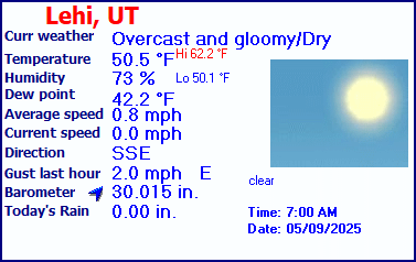
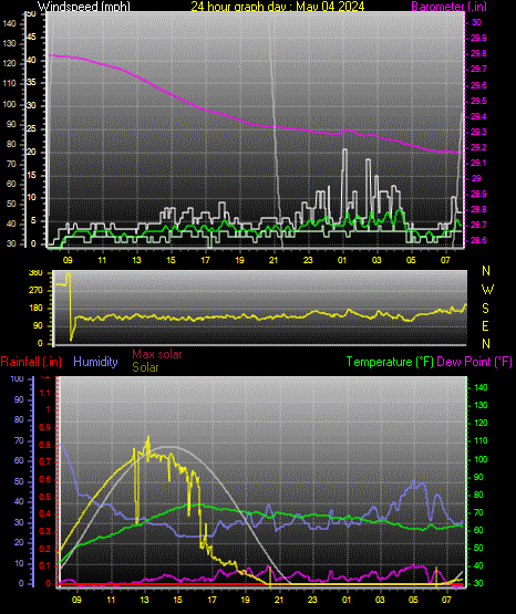
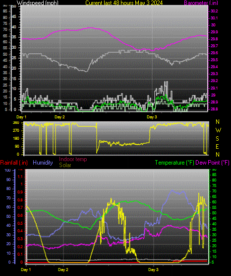
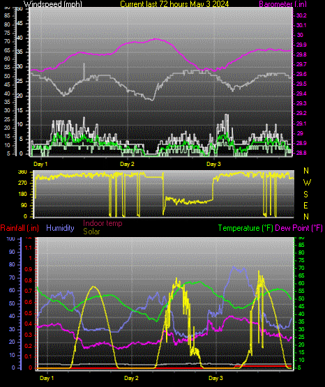
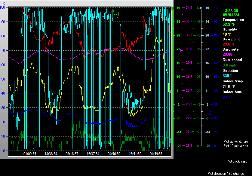
| Current Weather | Overcast and gloomy/Dry | Current Temperature | 77.1°F (25.1°C) (Heat Index 77.1°F ), Apparent temp 72.6°F , Apparent temp solar 72.6 °F |
| Maximum Temperature (since midnight) | -148.0°F at: 12:57 PM | Minimum Temperature (since midnight) | 212.0°F at: 6:29 AM |
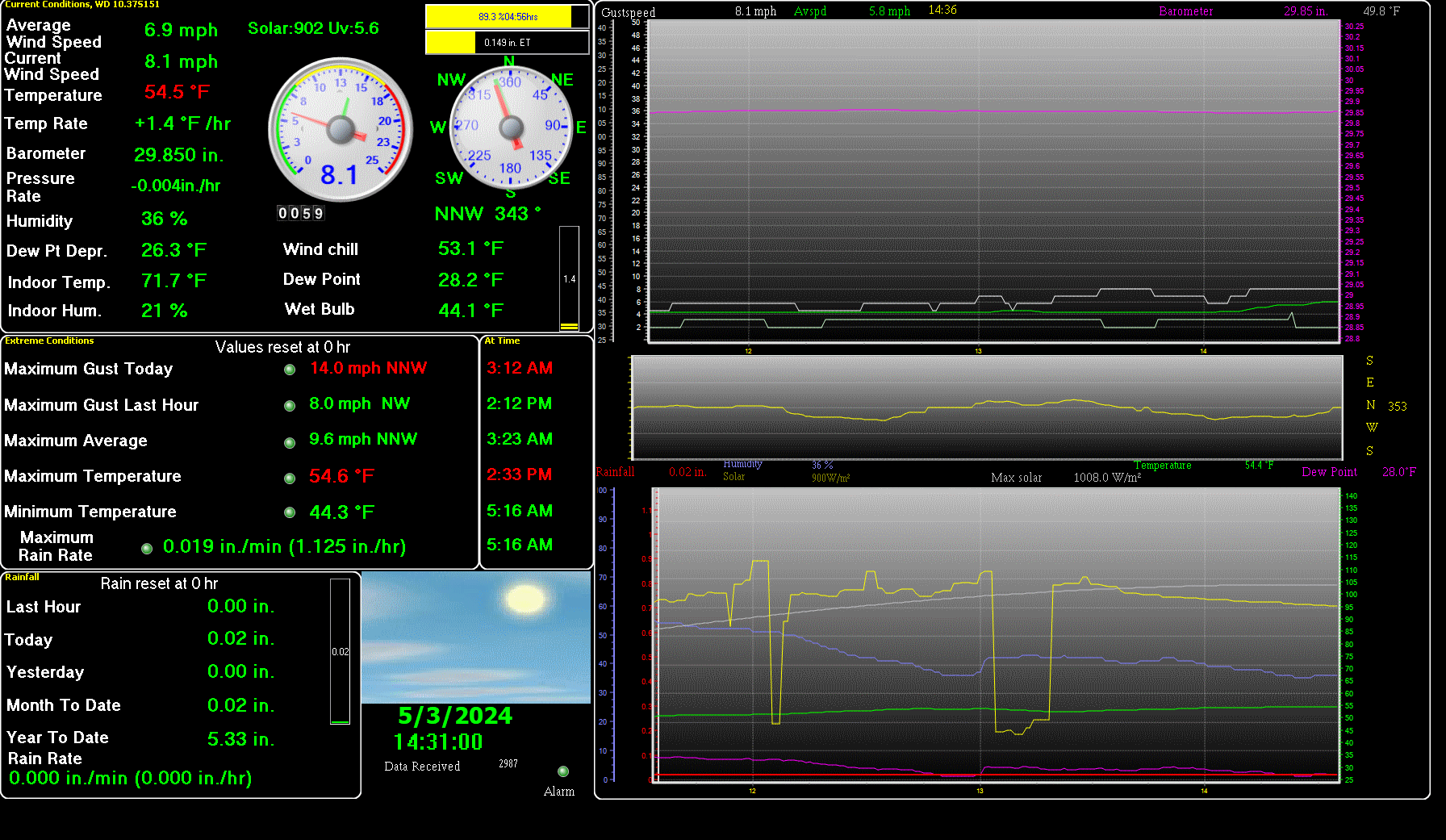
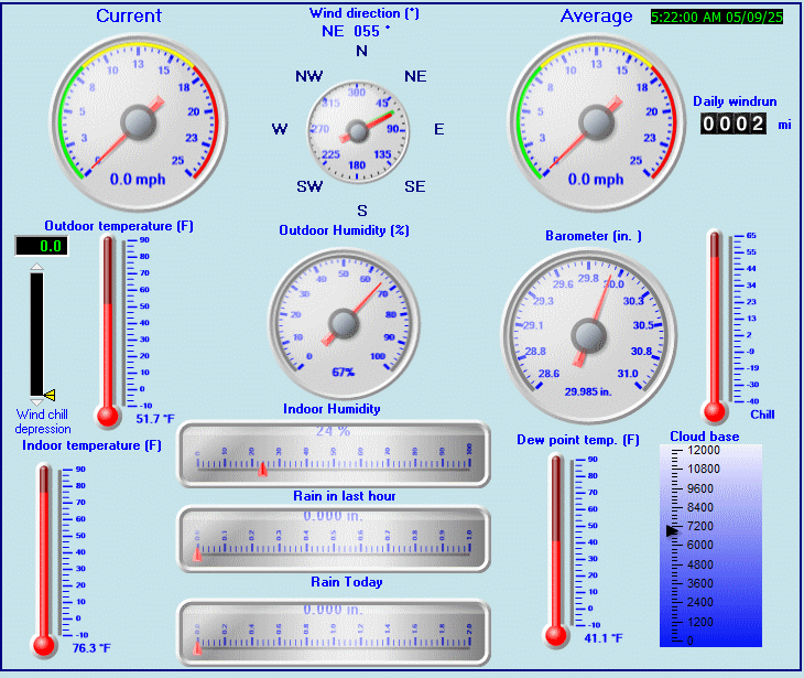
| Average windspeed (ten minute) | 6.9 mph | Wind Direction (ten minute) | N (360°) |
| Windchill Temperature | 77.1°F | Maximum Gust (last hour) | 0.0 mph at: 11:48 AM |
| Maximum Gust (since midnight) | 0.0 mph at: 1:24 PM | Maximum 1 minute average (since midnight) | 0.0 mph at: 1:30 PM |
| Rainfall (last hour) | 0.00 in. (0.0 mm) | Rainfall (since midnight) | 0.00 in. (0.0 mm) --- |
| Rainfall This month | 0.18 in. (4.6 mm) | Rainfall To date this year | 5.15 in. (130.8 mm) |
| Maximum rain per minute (last hour) | 0.00 in/min | Maximum rain per hour (last 6 hours) | 0.00 in/hour |
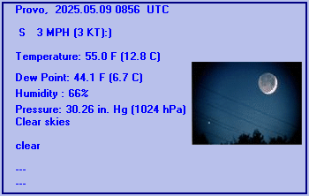
| Yesterdays rainfall | 0.00 in | DewPoint | 32.0°F (Wet Bulb :56.2°F ) |
| Humidity | 23 %, Humidex 73.2°F | Barometer corrected to msl | 29.654 in. (1004.2 hPa) |
| Pressure change | 0.00 in. (last hour) | Trend (last hour) | STEADY |
| Pressure change (last 12 hours) | +0.00 in | Pressure change (last 6 hours) | +0.00 in |
| Current Indoor Temp. 80.1°F | |||
| Current Indoor Hum. 22% | |||
| Current solar | 0 W/m² | Current UV | 0.0 |
| Maximum solar (since midnight) | -1 W/m² | Maximum UV (since midnight) | -1.0 |
| Current 00:00 hours of sunshine today, current sky: Overcast and gloomy | |||
| Sunshine hours for the year: | 456:11 hrs | Sunshine hours for the month: | 137:11 hrs |
| Current evapotranspiration 0.26 inches per day. Yesterday's reading 0.21 | |||
Expires:202103310000;;291400
FPUS65 KSLC 300944
SFTUT

UTZ001>016-019>021-517-518-WYZ021-310000-

Tabular State Forecast for Utah
National Weather Service Salt Lake City UT
343 AM MDT TUE MAR 30 2021

This product is issued routinely in the early morning and late
afternoon. It may not represent the latest forecast.


ROWS INCLUDE...
   Daily predominant daytime weather 6AM-6PM
   Forecast temperatures...early morning low/daytime high
         Probability of precipitation nighttime 6PM-6AM/daytime 6AM-6PM
          - indicates temperatures below zero
         MM indicates missing data


   FCST     FCST     FCST     FCST     FCST     FCST     FCST
   Today    Wed      Thu      Fri      Sat      Sun      Mon
   Mar 30   Mar 31   Apr 01   Apr 02   Apr 03   Apr 04   Apr 05

...NORTHERN UTAH...
   Salt Lake City
   Sunny    Sunny    Sunny    Sunny    Sunny    Ptcldy   Ptcldy
     /47    29/56    35/69    44/73    49/78    52/75    49/70
      /00    00/00    00/00    00/00    00/00    00/00    10/20

   Tooele
   Sunny    Sunny    Sunny    Sunny    Sunny    Ptcldy   Ptcldy
     /43    26/54    33/68    43/71    48/76    52/73    48/68
      /00    00/00    00/00    00/00    00/00    00/00    10/20

   Ogden
   Sunny    Sunny    Sunny    Sunny    Sunny    Ptcldy   Ptcldy
     /46    29/55    35/68    43/72    46/76    52/72    48/68
      /00    00/00    00/00    00/00    00/00    00/00    10/20

   Brigham City
   Sunny    Sunny    Sunny    Sunny    Sunny    Ptcldy   Ptcldy
     /48    26/55    30/67    40/71    43/76    47/72    44/68
      /00    00/00    00/00    00/00    00/00    00/10    10/30

   Provo
   Sunny    Sunny    Sunny    Sunny    Sunny    Ptcldy   Ptcldy
     /45    27/55    33/69    43/73    46/76    52/74    49/70
      /00    00/00    00/00    00/00    00/00    00/00    10/20

   Logan
   Sunny    Sunny    Sunny    Sunny    Sunny    Ptcldy   Ptcldy
     /45    23/54    25/64    32/69    36/74    39/70    38/65
      /00    00/00    00/00    00/00    00/00    00/10    10/20

   Wendover
   Sunny    Sunny    Sunny    Sunny    Ptcldy   Ptcldy   Sunny
     /49    26/55    30/68    39/74    44/78    47/74    43/69
      /00    00/00    00/00    00/00    00/00    00/00    10/10

   Park City
   Sunny    Sunny    Sunny    Sunny    Sunny    Ptcldy   Ptcldy
     /31    16/44    23/57    34/60    37/64    41/62    39/57
      /10    00/00    00/00    00/00    00/00    00/10    10/30

   Heber
   Sunny    Sunny    Sunny    Sunny    Sunny    Ptcldy   Ptcldy
     /44    17/57    23/68    30/70    34/73    39/70    39/65
      /10    00/00    00/00    00/00    00/00    00/00    10/20

   Randolph
   Sunny    Sunny    Sunny    Sunny    Sunny    Ptcldy   Ptcldy
     /35    14/45    21/58    29/62    32/66    37/63    35/58
      /00    00/00    00/00    00/00    00/00    00/10    10/30

   Alta
   Sunny    Sunny    Sunny    Sunny    Sunny    Ptcldy   Ptcldy
     /26    11/39    23/52    32/57    35/60    39/57    36/52
      /10    00/00    00/00    00/00    00/00    00/10    10/30

   Bear River RS
   Sunny    Sunny    Sunny    Sunny    Sunny    Ptcldy   Ptcldy
     /27    5/43     17/55    28/56    28/60    33/58    30/53
      /10    00/00    00/00    00/00    00/00    00/10    10/30

   Mirror Lake
   Vrycld   Sunny    Sunny    Sunny    Sunny    Ptcldy   Ptcldy
     /19    6/36     19/46    27/48    29/51    33/49    30/46
      /10    00/00    00/00    00/00    00/00    00/10    10/30

   Soldier Summit
   Sunny    Sunny    Sunny    Sunny    Sunny    Ptcldy   Sunny
     /32    9/46     18/55    25/59    30/63    34/62    32/57
      /00    00/00    00/00    00/00    00/00    00/00    10/20

   Duchesne
   Sunny    Sunny    Sunny    Sunny    Sunny    Ptcldy   Sunny
     /46    20/58    27/66    35/71    39/74    44/73    43/70
      /00    00/00    00/00    00/00    00/00    00/00    00/10

...SOUTHERN UTAH...
   Price
   Sunny    Sunny    Sunny    Sunny    Sunny    Sunny    Sunny
     /44    22/54    28/63    35/70    40/74    42/72    41/68
      /00    00/00    00/00    00/00    00/00    00/00    00/10

   Hanksville
   Sunny    Sunny    Sunny    Sunny    Sunny    Sunny    Sunny
     /54    20/59    27/71    35/78    41/83    44/83    45/80
      /00    00/00    00/00    00/00    00/00    00/00    00/00

   Richfield
   Sunny    Sunny    Sunny    Sunny    Sunny    Ptcldy   Sunny
     /47    20/61    29/72    36/75    40/77    44/76    43/72
      /00    00/00    00/00    00/00    00/00    00/00    00/10

   Delta
   Sunny    Sunny    Sunny    Sunny    Sunny    Ptcldy   Sunny
     /45    17/55    25/69    35/74    39/79    44/76    43/71
      /00    00/00    00/00    00/00    00/00    00/00    00/10

   Cedar City
   Sunny    Sunny    Sunny    Sunny    Sunny    Ptcldy   Sunny
     /46    19/59    28/70    36/75    40/76    44/74    43/70
      /00    00/00    00/00    00/00    00/00    00/00    00/10

   Bryce Canyon
   Sunny    Sunny    Sunny    Sunny    Sunny    Sunny    Sunny
     /42    13/51    19/60    27/65    30/67    32/65    32/62
      /00    00/00    00/00    00/00    00/00    00/00    00/10

   St George
   Sunny    Sunny    Sunny    Sunny    Sunny    Sunny    Sunny
     /65    35/72    40/81    48/84    52/87    54/85    53/82
      /00    00/00    00/00    00/00    00/00    00/00    00/00

   Kanab
   Sunny    Sunny    Sunny    Sunny    Sunny    Sunny    Sunny
     /58    29/62    33/73    41/78    44/81    46/80    46/76
      /00    00/00    00/00    00/00    00/00    00/00    00/10

   Bullfrog
   Sunny    Sunny    Sunny    Sunny    Sunny    Sunny    Sunny
     /57    30/62    34/71    45/79    49/84    51/84    52/81
      /00    00/00    00/00    00/00    00/00    00/00    00/00

...EXTREME SOUTHWEST WYOMING...
   Evanston
   Sunny    Sunny    Sunny    Sunny    Sunny    Ptcldy   Ptcldy
     /33    14/46    23/58    34/61    36/65    40/62    37/57
      /00    00/00    00/00    00/00    00/00    00/00    10/20

...EASTERN UTAH...
   Manila
   Sunny    Sunny    Sunny    Sunny    Sunny    Ptcldy   Sunny
     /36    19/50    28/62    35/66    38/70    43/69    41/64
      /00    00/00    00/00    00/00    00/00    00/00    00/20

   Vernal
   Sunny    Sunny    Sunny    Sunny    Sunny    Ptcldy   Sunny
     /46    21/55    28/64    32/69    36/74    40/73    39/69
      /00    00/00    00/00    00/00    00/00    00/00    00/10

   Moab
   Sunny    Sunny    Sunny    Sunny    Sunny    Sunny    Sunny
     /55    25/62    32/73    43/78    46/84    52/84    53/81
      /00    00/00    00/00    00/00    00/00    00/00    00/00

   Blanding
   Sunny    Sunny    Sunny    Sunny    Sunny    Sunny    Sunny
     /50    23/56    28/66    38/73    41/76    44/76    44/74
      /00    00/00    00/00    00/00    00/00    00/00    00/00

$$

For more information from NOAA's National Weather Service visit...
http://weather.gov/saltlakecity

Hill Air Force Base / Ogden, UT, United States (KHIF) 41-07N 111-58W
May 26, 2025 - 03:55 PM EDT / 2025.05.26 1955 UTC
Wind: from the WSW (240 degrees) at 7 MPH (6 KT):0
Visibility: 10 mile(s):0
Sky conditions: clear
Temperature: 77.4 F (25.2 C)
Dew Point: 34.3 F (1.3 C)
Relative Humidity: 20%
Pressure (altimeter): 30.02 in. Hg (1016 hPa)
ob: KHIF 261955Z AUTO 24006KT 10SM CLR 25/01 A3002 RMK AO2 SLP113 T02520013
cycle: 20
SALT LAKE CITY INTERNATIONAL  AIRPORT , UT, United States (KSLC) 40-47N 111-58W 1286M
May 26, 2025 - 03:54 PM EDT / 2025.05.26 1954 UTC
Wind: Calm:0
Visibility: 10 mile(s):0
Sky conditions: mostly clear
Weather: Cumulonimbus clouds observed
Temperature: 80.1 F (26.7 C)
Dew Point: 33.1 F (0.6 C)
Relative Humidity: 18%
Pressure (altimeter): 29.96 in. Hg (1014 hPa)
ob: KSLC 261954Z 00000KT 10SM FEW095 FEW250 27/01 A2996 RMK AO2 SLP095 CB DSNT NW T02670006
cycle: 20
Salt Lake City, Salt Lake City Municipal 2 Airport, UT, United States (KU42) 40-37-10N 111-59-34W
Apr 23, 2025 - 01:55 PM EDT / 2025.04.23 1755 UTC
Wind: from the SSE (150 degrees) at 17 MPH (15 KT) gusting to 23 MPH (20 KT):0
Visibility: 10 mile(s):0
Sky conditions: clear
Temperature: 68 F (20 C)
Dew Point: 26 F (-3 C)
Relative Humidity: 20%
Pressure (altimeter): 29.87 in. Hg (1011 hPa)
ob: KU42 231755Z AUTO 15015G20KT 10SM CLR 20/M03 A2987 RMK AO2 10193 20089
cycle: 18
Station name not available
May 26, 2025 - 04:15 PM EDT / 2025.05.26 2015 UTC
Wind: from the ENE (070 degrees) at 9 MPH (8 KT):0
Visibility: 10 mile(s):0
Sky conditions: clear
Temperature: 84 F (29 C)
Dew Point: 35 F (2 C)
Relative Humidity: 17%
Pressure (altimeter): 29.97 in. Hg (1014 hPa)
ob: KTVY 262015Z AUTO 07008KT 10SM CLR 29/02 A2997 RMK AO2
cycle: 20
Provo, Provo Municipal Airport, UT, United States (KPVU) 40-13N 111-43W
May 26, 2025 - 03:56 PM EDT / 2025.05.26 1956 UTC
Wind: from the W (270 degrees) at 5 MPH (4 KT):0
Visibility: 10 mile(s):0
Sky conditions: partly cloudy
Temperature: 75.9 F (24.4 C)
Dew Point: 36.0 F (2.2 C)
Relative Humidity: 23%
Pressure (altimeter): 30.02 in. Hg (1016 hPa)
ob: KPVU 261956Z 27004KT 10SM SCT090 24/02 A3002 RMK AO2 SLP120 T02440022
cycle: 20
Station name not available
May 26, 2025 - 04:35 PM EDT / 2025.05.26 2035 UTC
Wind: from the WNW (300 degrees) at 9 MPH (8 KT):0
Visibility: 10 mile(s):0
Sky conditions: clear
Temperature: 77.7 F (25.4 C)
Dew Point: 32.7 F (0.4 C)
Relative Humidity: 19%
Pressure (altimeter): 30.02 in. Hg (1016 hPa)
ob: KHCR 262035Z AUTO 30008KT 10SM CLR 25/00 A3002 RMK AO2 T02540004
cycle: 20
Use the RELOAD facility on your browser to retrieve the latest data.